Update 4.0.4
08.08.2018 – Downloadable from Eionet Forum homepage.
New or modified features
- The 3 band IMG satellite images contain RGB color channels in the reverse
order compared to other common raster image formats. CLC2018 software
automatically changes R and B bands for the conventional colouring, but
in the prior version the Add raster layer window showed
1, 2, 3 band number – as in case of other image formats.
In the current version the software shows the true 3, 2, 1 band numbers,
bat beside them write a red "BGR!" warning.
Errors fixed
- Some 4 or more band raster images contained vertical colour lines,
or colour "pixel noise".
- At the edge of some 16 bit images appeared barcode featured colour lines.
- Some 4 band TIFF images appeared dimly, with a grey veil.
- After saving, closing and reopening a CLC2018 project file,
raster layers "forgot" the transparent black setting.
Update 4.0.3
16.05.2018 – Was downloadable from Eionet Forum homepage.
New or modified features
- Before saving the Change layer program checks the number of change
polygons to prevent accidental data loss, and sends a warning if this
number decreased compared to the previous saving.
- New alternative Progress colouring grid shows ready polygons almost
fully transparent.
- In the Default settings dialog user can check Permanent polygon mask,
and in this case – if the Polygon mask button is down – the mask appears
automatically around all newly selected polygons.
- If any colouring is on at the beginning of a temporary saving, program
automatically switches on that colouring after the saving.
- Multipart polygon warning message at polygon editing was improved.
- Operation of the Reshape tool simplified to avoid polygon editing errors.
This tool operates now only on the common border of two adjacent polygons.
- Operation improved by deleting change polygons, which was affected by
the subsequent editing of a revision polygon.
Errors fixed
- Some 16 bit/pixel images beginning with large sea areas appeared with
erroneous colours and Improve raster colours feature was unable to
correct this.
- Add raster layer window Transparent black check box was inefficient.
- In very rare occurrences error checking generated long, aeroplane
landing-strip shaped phantom polygons.
- After error checking program showed as erroneous some polygons, which
was corrected yet before the error checking.
- In some cases the area of the newly created change polygons was wrong.
- The Cancel button in the Save changes confirmation dialog at closing
a project or exiting the program was misleading.
- In some countries, who uses non equal-area projection in the CLC work,
the area data of the polygons was inaccurate.
- In rare occurrences using of the Reshape tool created handle formed
features at the edge of the map sheet.
Known issues
- At the edge of some 16 bit images appear barcode featured colour lines.
- Some 4 or more band raster images which worked well in the previous version, in this
version contain vertical colour lines, or colour "pixel noise".
Update 4.0.2
22.02.2018 – Was downloadable from Eionet Forum homepage.
New or modified features
- It is not required to specify Map sheets grid background file at the
first start of the software.
Errors fixed
- Operation of the Reshape tool has been improved to prevent polygon
loss if the user draws the new borderline incorrectly.
- Error message "Selected area is outside of the image or invalid."
if opening the Improve raster colours window in some CRS.
- Raster band mismatch of some image formats in the Improve raster
colours window.
- Sliver handling in the Error checking procedure has been
corrected.
- Inconsistencies in the handling of the 4th level codes.
- In the InterCheck View menu Bold lines command was
inefficient.
- Error message "Layer Extent already exists" if creating new
InterCheck project.
- In InterCheck Search window: "all" (Error type) check box
was inefficient.
Known issues
Fixing foreseen in the next update.
- Add raster layer window Transparent black check box inefficient.
- At the edge of some 16 bit images appear barcode featured colour lines.
- Some 16 bit/pixel images beginning with large sea areas appear with erroneous
colours and Improve raster colours feature unable to correct this.
Release 4.0.1
16.10.2017 – Revised and enlarged version was downloadable from Eionet Forum homepage.
|
|
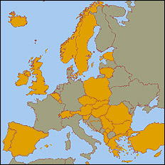
CLC2018 registered users (31)
- Albania
– National Environmental Agency
- Austria
– Umweltbundesamt GmbH
- Belgium
– GIM Smart Geo Insights
- Bulgaria
– Space Research and Technology
Institute;
– Executive Environment Agency
- Cyprus
– Cyprus University of Technology
- Czech Republic
– Gisat s.r.o.
– CENIA (Czech Environmental
Information Agency)
- Georgia
– GIS-Lab Ltd.
– Ministry of Environment Protection
and Agriculture of Georgia
- Greece
– Hellenic Cadastre
- Estonia
– Estonian Map Center
- Hungary
– Government Office of the
Capital City Budapest
- Iceland
– National Land Survey of Iceland
- Ireland
– Environmental Protection Agency
- Kosovo
– Kosovo Environmental Protection
Agency
- Lithuania
– SE GIS-Centras
- Luxenbourg
– Space4environment
- Malta
– Malta Environment and Planning
Authority
- Norway
– Norvegian Institute for Bioeconomy
- Poland
– Institute of Geodesy and
Cartography
- Portugal
– Directorate General of the Territory
- Romania
– Danube Delta National Institute
for Research & Development
- Serbia
– GILAB DOO Beograd
- Slovakia
– Slovak Environmental Agency
- Slovenia
– Geodetic Institute of Slovenia
- Spain
– National Reference Centre
on Land Cover
- Switzerland
– Swiss Federal Institute for Forest,
Snow and Landscape Research
- Sweden
– Lantmateriet
- Turkey
– Ministry of Forest and Water Affairs
- United Kingdom
– Specto Natura Limited

CLC2012 registered users

|
|

